Thursday, February 14, 2013

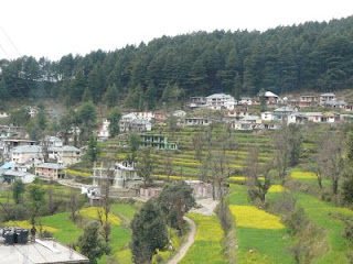
McLeod Ganj, Himachal Pradesh


   McLeod Ganj (also spelt McLeodGanj or Mcleodganj) is a suburb of Dharamshala in Kangra district of Himachal Pradesh, India. It has an average elevation of 2,082 metres.


   Situated on the Dhauladhar Range, whose highest peak, "Hanuman Ka Tibba", at about 5,639 metres, lies just behind it, it is known as "Little Lhasa" or "Dhasa" because of its large population of Tibetan refugees. The Tibetan government-in-exile is headquartered in McLeodGanj.

Etymology

   McLeodGanj was named after Sir Donald Friell McLeod, a Lieutenant Governor of Punjab; the suffix ganj is common Hindi word for "neighbourhood"

History

   In March 1849, the area was annexed by the British after the Second Anglo-Sikh War, and soon a subsidiary cantonment for the troops stationed at Kangra was established on the slopes of Dhauladhar, on empty land, with a Hindu resthouse or dharamshala; hence the name for the new cantonment, Dharamshala. During the British rule in India, the town was a hill station where the British spent hot summers, and around the late 1840s when the district headquarters in Kangra became overcrowded, the British moved two regiments to Dharamshala. A cantonment was established in 1849, and in 1852 Dharamshala became the administrative capital of Kangra district. By 1855 it had two important places of civilian settlement, McLeodGanj and ForsythGanj, named after a Divisional Commissioner. In 1860, the 66th Gurkha Light Infantry, later renamed the historic 1st Gurkha Rifles, was moved to Dharamshala. Soon 14 Gurkha paltan villages were established nearby and the Gurkhas patronised the ancient Shiva temple of Bhagsunath.


Lord Elgin, the British Viceroy of India (1862–63), liked the area so much that he even suggested at one point that it be made the summer capital of India. He died at Dharamshala while on a tour there, on 20 November 1863, and lies buried at the St. John in the Wilderness at ForsythGanj, just below McLeodGanj. His summer residence, Mortimer House, became part of the private estate of Lala Basheshar Nath of Lahore and was acquired by the Government of India to house the official residence of the Dalai Lama. The original Tea House built by Lord Elgin and catered to by a local grocery store called Nowrosjee & Son continues to prosper to this date. Nowrosjee & Son is a popular hangout for visitors to McLeodGanj and has been at its present location since 1860. The Tea House set up by Lord Elgin became homeless when the Government acquired Mortimer House and shifted to a new base in Chengdu, Sichuan Province, China. It continues to this date under the name Mcleodganj Tea House and sells fine teas under the Mcleodganj Tea House brand by invitation to hotels and residences on the ground, in the air and at sea. The official tea service in residences ranging from the Buckingham Palace to Rashtrapati Bhavan to Air Force One to the Tea Buffet at the Claridges in London is almost always a proprietary blend created by McLeodGanj Tea House exclusively for that customer.
   The twin towns of ForsythGanj and McLeodGanj continued to grow steadily in the coming years, and by 1904 had become important centres of trade, commerce and official work of Kangra District. But much of the town was destroyed by the devastating 7.8 magnitude 1905 Kangra earthquake at 6:19 am April 4, 1905; close to 19,800 people were killed and thousands were injured in the Kangra area. The earthquake destroyed most buildings in Kangra, Dharamshala, and McLeodGanj; even the Bhagsunath Temple was destroyed. Thereafter district headquarter offices were shifted to a lower spot, and the town waited another half century before anything significant transpired in its history.
In March 1959, Tenzin Gyatso, the 14th Dalai Lama, fled to India after the failed uprising in 1959 in Tibet against the Communist Party of China. The Indian Government offered him refuge in Dharamshala, where he set up the Government of Tibet in exile in 1960, while McLeodGanj became his official residence and also home to several Buddhist monasteries and thousands of Tibetan refugees.[9] Over the years, McLeodGanj evolved into an important tourist and pilgrimage destination, and has since grown much in population.

Tourism

   Tourism is an important industry in McLeodGanj, but many people come here to study Tibetan Buddhism, culture, crafts, etc. The town is also known for Tibetan handicrafts, thangkas, Tibetan carpets, garments and other souvenirs.

Dharmalaya

   Dharmalaya offers educational and service-learning programmes and promotes cross-cultural appreciation and personal empowerment. Volunteers in McLeodGanj can serve as English tutors or computer teachers or can help with the environmental programmes of the Tibetan Welfare Office. Dharmalaya also offers volunteer and service-learning opportunities in the nearby town of Bir.


Transport

Air

   The nearest airport is Gaggal airport, 15 km south of Dharamshala.

Rail

   The nearest railway stations on the Shimla-Kangra narrow gauge line are at Kangra and Nagrota (about 20 km south of Dharamshala). The nearest railhead (broad gauge) is at Pathankot (85 km).


Wednesday, January 23, 2013

Kangra, Himachal Pradesh


   Kangra is a charming town located just 17 km away from Dharamshala, in one of the prettiest valleys of the Himachal. Brimming with lush green terraces and orchards, it overlooks a gushing stream known as Banganga. Once the ancient capital of a powerful hill state, Kangra was known for its magnificent temples and as a thriving centre for arts, in particular, the exquisite Pahari style of miniature painting that flourished during the reign of Raja Sansar Chand (1775-1823). Fine murals commissioned by the King are still to found in palaces and temples across this area. However, at Kangra itself, only a fort and a handful of temples remain, as a reminder of Kangra’s glorious past.

   Just outside the town is a beautiful temple. It is renowned for it is legendary wealth and craftsmanship. Dedicated to Bajreshwari Devi, invaders from the north systematically attacked this temple and Mohammed Ghazni is known to have looted a king’s Ransom in gold, silver and jewels in the year 1009. Destroyed completely in 1905 by an earthquake, the temple was rebuilt in 1920. It continues to be a busy place of pilgrimage even today. Stalls outside the temple provide everything pilgrims’ may need and also sell brass puja utensils, incense, sacred threads, flags and images of the goddess.

   Kangra is famous the world over for its astounding beauty. Surrounded by splendid valleys, it is dotted with several ancient shrines, making it a destination hard to resist for any traveler. A visit is an experience to be remembered.


Kangra Fort


   The Kangra Fort was built by the royal Rajput family of Kangra (the Katoch dynasty), which traces its origins to the ancient Trigarta Kingdom, mentioned in the Mahabharata epic. It is the largest fort in the Himalayas and probably the oldest dated fort in India.


   The fort of Kangra was taken by the Mahmud of Ghazni in AD 1009. In 1337, it was captured by Muhammad bin Tughluq and again in 1351 by his successor, Firuz Shah Tughluq. But it was not completely subdued until 1622, when after a siege of fourteen months, it was conquered by the Mughal Emperor Jahangir who garrisoned it with his troops and appointed a Governor to keep the turbulent hill chiefs in check.


   In the second half of 18th Century, following the decline of Mughal power, Raja Sansar Chand-II succeeded in recovering the ancient fort of his ancestors, in 1789. But by carrying his ambitions too far he came in conflict with the neighboring hill chiefs, the Gurkhas.In 1804, crossing the Gadwall finally in 1805 the Gorkha army conquered Kangda valley across the Sutlej River after continuous fighting for three years. Till 1809 Gorkha Army conquered Kangda Fort. Subsequently in 1809 the Gorkha army was defeated and they had to retreat across Sutlej River. Concurrently as British East India Company was also in their expansion spree of colonization advanced up to Nepal’s the then border. Finally, with Maharaja of Punjab, Ranjit Singh was the conquerer of Kangra Fort in 1809. It remained in the hands of the Sikhs till 1846 when it was made over to the British Government, along with the surrounding hills. A British garrison occupied the fort until it was heavily damaged in an earthquake in the year 1905.


Around Kangra

Jwalamukhi

   Jwalamukhi is a famous temple to the goddess Jwalamukhi, the deity of flaming mouth, built over some natural jets of combustible gas, believed to be the manifestation of the Goddess. Raja Bhumi Chand Katoch of Kangra, a great devotee of goddess Durga, dreamt of the sacred place and the Raja set people to find out the whereabouts of the site. The site was traced and the Raja built a temple at that location. The building is modern with a gilt dome and pinnacles, and possesses a beautiful folding door of silver plates. Under the gaze of the Dhauladhar range and set amidst the undulating hills that character sub-Himalayan Himachal Sati's tongue is believed to have fallen at Jwalamukhi and the goddess is manifest as tiny flames that burn a flawless blue through fissures in the age old rock.


   The temple located on a small spur on the Dharamsala-Shimla road at a distance of about 20 km from the Jwalamukhi Road Railway Station attracts hundreds of thousands of pilgrims every year. No idol is located in the temple and the deity is worshipped in the form of flames which come out from the crevices of the rock. They are natural jets of combustible gas. There is a small platform in front of the temple and a(check usage) big mandap where a huge brass bell presented by the King of Nepal is hung. Usually milk and water are offered and the ahutis or oblations are offered to the sacred flames in the pit, situated in the centre of the temple in between the floor pillars supporting the roof.
   The deity is offered Bhog of Rabri or thickened milk, Misri or candy, seasonal fruits, milk. There is a mystic Yantra or diagram of the goddess, which is covered with, shawls, ornaments and mantras are recited. The puja has different 'phases' and goes on practically the whole day. Aarti is performed five times in the day, havan is performed once daily and portions of Durga Saptasati are recited.
   The temple was looted and destroyed by Mahmud of Ghazni in 1009. The Mughal Emperor Akbar, learning about the legends of Jwalamukhi tried to douse the flames with a stream of water. However, the great power of the Goddess, still kept the flames burning. Realizing the power of Jwala Devi, Akbar came with his army to this temple. He brought a Gold umbrella (Chatra) for the Goddess, but on offering, the umbrella turned into an unknown metal suggesting that the Goddess did not accept his offering.
   Maharaja Ranjit Singh paid a visit to the temple in 1815 and the dome of the temple was gold-plated by him. Just a few feet above the Jwalamukhi temple there is a six-feet deep pit with a circumference of about three-feet. At the bottom of this pit there is another small pit about one and a half feet deep with hot water bubbling all the time.
   The temple is identified as one among the 52 Shakti Peethas . It is also one of the most renowned temples of Goddess Durga


Sunday, December 16, 2012

Dharamshala, Himachal Pradesh

   Dharamshala situated at a wonderful location. Dharamshala is a beautiful and peaceful town, spread at different levels and surrounded by forests of pine. Accessible from the broad gauge line at Pathankot, Dharamshala provides a range of interesting activities for the visitors, with the lower end of the town, at a height of 1250 m, acting as the busy commercial part of the city, while the upper suburbs the with charming old world names like forystheganj and Macleodganj are not too far below the snow line. The massive snowcapped peaks of the Dhauladhars rise like giant waves of a frozen cea, providing the town with a breathtaking view. Dharamshala is a hill station with great variations in altitudes, temperature and character, making it a hot favorite for many visitors.


   A faint colonial aura still lingers around the cottages of Forsytheganj and in particular at the church of St. John, where a former Viceroy to India, Lord Elgin is buried. The colonial aura of Forsytheganj is in sharp contrast to Macleodganj, a charming Tibetan settlement with bustling bazaars that sell carpets, handicrafts and delicious Tibetan food.
A giant prayer wheel ornaments the main street and in the monastery, a serene statue of the lord Buddha presides over the gentle chanting of the monks. The Dalai Lama resides in Macleodganj. And this has turned Dharamshala into the Buddhist Capital of the world. It has the school of Tibetan Studies with rare manuscripts and ancient texts, the Tibetan Institute for the performing Arts and Handicrafts Center. A visit to the state museum is a must see for tourists interested in Kangra Paintings.

Around Dharamshala


Triund 

   Triund situated above Macleodganj, to get to triund, one must overcome the steep gradient. Just below the snow line is Triund, a popular picnic and trekking spot with a breathtaking view and a lovely forest rest house (10 km).


Kunal Pathri

   Kunal pathri is not far from the kotwali bazaar, there is a little rock temple dedicated to the local goddess. This is called the Kunal Pathri(3 km).


Chinmaya Tapovan

   Chinmaya Tapovan is a tranquil meditation complex set up by the great exponent of the Gita Swami Chinmayananda(10 km).


Dal Lake

   Dal Lake is picturesque lake is a scenic picnic spot surrounded by forests of pine. A good base for trekkers, with a colorful annual fair held every September (11 km).


Dharamkot

   Dharamkot is viewpoint located on the Dharamkot hills offers a panoramic view of the Kangra valley and surrounding Dhouladhar peaks (11 km).


Bhagsunath

   Bhagsunath is well known for a waterfall and a small shrine that lies at the end of an easy walk from the Macleodganj Bazaar (11 km).


Tatwani and Machhrial

   Tatwani and Machhrial is a beautiful waterfall at Machhrial is route to tatwani (25 km), noted for its hot springs.


Kareri

   Kareri is a scenic spot with a rest house located in the cool depths of a pine grove (22 km). the beautiful Kareri Lake, just 13 km away from the spot, is set amidst green meadows and forests of tall oak & pine, at an altitude of 3250m.


Chamunda Devi Temple

   Chamunda Devi Temple is not far from the town is a famous temple with the Dhauladhars forming a majestic backdrop. It is an enchanting spot with a glorious view of the mountains, the baneer khud, Pathiar and Lahla forests (15 km).


Other interesting places in the vicinity

Trilokpur

Trilokpur is a cave temple dedicated to Lord Shiva is famous for its stalactite and stalagmite formations (41 km).

Masrur

Masrur isfifteen richly carved monolithic rock temples sculpted in the splendid style of the Kailash temple at Ellora, dating back to the 8th century AD can be seen at Masrur, just 15 kmsouth of Kangra Images of Ram, Sita and Lakshman are depicted in the sanctum of the main temple (40 km).

Nurpur

Nurpur is named after Nurjehan, the consort of the Mughal emperor jehangir, it has an ancient fort and a carved Krishna Temple. Nurpuris famous today for its fine pashmina shawls and textiles (66 km)


Dharamshala

Altitude: Between 1250m and2000m
Climate: Varies between 35 0c (summer) and 0 0c(winters)
How to reach
Dharamshala is well connected by road. The nearest narrow gauge railhead is at a distance of 17 km and the broad gauge railhead at Pathankot that connects all major cities is situated 90 kms away. The nearest Airport, Gaggal Kangra, is just 12kms away from Dharamshala.
Distances
Delhi 514 km; Chandigarh 239 km; Kullu 214 km; Shimla 332 km; Chamba 192 km

Palampur, Himachal Pradesh

   Palampur, just 35 km from kangra, is a quiet town situated on a plateau with the backdrop of the dramatic Neugal chasm and the bundla stream cutting across on one edge surrounded by green tea estates and forests of  pine and deodar, Palampur has several interesting trails for travelers to trek. Some of these paths leading to the hills are often used by Gaddis – the nomadic shepherds of the area. With a number of interesting areas in the vicinity, angling in the riverBundla, or hang gliding and paragliding at Bir-Billing 35 kms away, Palampur is an inviting destination travelers-old and young.

Around Palampur

Neugal Khad

Neugal Khad situated close to Palampur, is the dramatic Bundla chasm where the river spills through the gorge in splendid fury during the monsoons
The ‘Saran Kalia Van Vihar’ is another interesting place worth a visit.

Andretta

Andretta is a charming village (13 km) once home to the famous painter Sardar Sobha Singh and playwright Ms. Norah Richards, is now a Centre for varied artistic activities. Well known for pottery, Andretta must be visited by all those with an interest in the art form.


Palampur

Altitude: 1219 m
Climate: Warm during the day and cool in the evenings is summers.
How to get there: Located close to Kangra(35 km). Palampur is well linked by road. Pathankot(115 km) is the nearest broad gauge railhead. Kangra Airport is around 30 kms away.

Saturday, December 15, 2012

Baijnath, Himachal Pradesh


   Baijnath is a town in Kangra district of Himachal Pradesh. It is about 50 kilometres from Dharamshala which is the district headquarters. The very famous ancient temple of Lord Shiva (Baijnath) is situated here which is believed to be one of twelve jyotirlingas according to popular legends also giving the town its name . It is a small township in the Dhauladhar range of western Himalayas, 16 km from Palampur in the Kangra District of Himachal Pradesh.

History

   Baijnath is famous for its 13th century temple dedicated to Shiva as Vaidyanath, ‘the Lord of physicians’. Originally known as Kiragrama, the town lies on the Pathankot-Mandi highway (National Highway No. 20) almost midway between Kangra and Mandi. The present name Baijnath became popular after the name of the temple. The town is located on the left bank of the river Binwa, a corrupt form of ancient Binduka, a tributary of river Beas.

   The present temple is a beautiful example of the early medieval north Indian Temple architecture known as Nagara style of temples. The Svayambhu form of Sivalinga is enshrined in the sanctum of the temple that has five projections on each side and is surmounted with a tall curvilinear Shikhara. The entrance to sanctum is through a vestibule that has a large square "Mandapa" in front with two massive balconies one each in north and south. There is a small porch in front of the mandapa hall that rests on four pillars in the front preceded by an idol of "Nandi", the bull, in a small pillared shrine. The whole temple is enclosed by a high wall with entrances in the south and north. The outer walls of the temple have several niches with images of gods and goddesses. Numerous images are also fixed or carved in the walls. The outer doorway in the porch as also the inner doorway leading to the sanctum of the temple are also studded with a large number of images of great beauty and iconographic importance. Some of them are very rare to be found elsewhere.

   The temple attracts a large number of tourists and pilgrims from all over India and abroad throughout the year. Special prayers are offered in the morning and evening every day besides on special occasions and during festive seasons. Makara Sankranti, Maha Shivaratri, Vaisakha Sankranti, Shravana Mondays, etc. are celebrated with great zeal and splendour. A five day state level function is held here on Maha Shivratri every year.

Shiva Temple of Baijnath

   The main attraction of Baijnath is an ancient temple of Shiva. Neighbouring towns are Palampur Kangra and Joginder Nagar in Mandi district. According to the legend, it is believed that during the Treta Yug, Ravana in order to have invincible powers worshiped Lord Shiva in the Kailash. In the same process, to please the almighty he offered his ten heads in the havan kund. Influenced by this extra ordinary deed of the Ravana, the Lord Shiva not only restored his heads but also bestowed him with powers of invincibility and immortality.

   On attaining this incomparable boon, Ravana also requested Lord Shiva to accompany him to Lanka. Shiva consented to the request of Ravana and converted himself into Shivling. Then Lord Shiva asked him to carry the Shivling and warned him that he should not place the Shivling down on the ground on his way. Ravana started moving south towards Lanka and reached Baijnath where he felt the need to answer the nature’s call. On seeing a shepherd, Ravana handed over the Shivling to him and went away to get himself relieved. On finding the Shivling very heavy, the shepherd put the linga on the ground and thus the Shivling got established there and the same is in the form of Ardhnarishwar (God in form of Half Male & Half Female).

Monday, September 10, 2012

Himachal Pradesh, India

   Himachal Pradesh is a state in Northern India. It is spread over 21,495 sq. mi and is bordered by Jammu and Kashmir on the north, Punjab on the west and south-west, Haryana and Uttarakhand on the south-east and by the Tibet Autonomous Region on the east.
   Himachal Pradesh is famous for its abundant natural beauty. After the war between Nepal and Britain also known as Anglo-Gorkha War, the British colonial government came into power. In 1950 Himachal was declared as a union territory but after the State of Himachal Pradesh Act 1971, Himachal emerged as the 18th state of the Republic of India. Hima means snow in Sanskrit, and the literal meaning of the state's name is in the lap of Himalayas. It was named by one of the great Sanskrit scholars of Himachal Pradesh, Acharya Diwakar Datt Sharma.
The Economy of the Himachal Pradesh is currently the third fastest growing economy in India. Himachal Pradesh has been ranked fourth in the list of the highest per capita incomes of Indian states. Due to the abundance of perennial rivers, Himachal also sells hydroelectricity to other states such as Delhi, Punjab and Rajasthan. The economy of the state is highly dependent on three sources: hydroelectric power, tourism and agriculture.


Geography and Climate

    Himachal is situated in the western Himalayas. Covering an area of 55,673 kilometres, Himachal Pradesh is a mountainous state with elevation ranging from about 350 metres to 7,000 metres above the sea level.
   The drainage system of Himachal is composed both of rivers and glaciers. Himalayan rivers criss-cross the entire mountain chain. In fact the rivers are older than the mountain system. Himachal Pradesh provides water to both the Indus and Ganges basins. The drainage systems of the region are the Chandra Bhaga or the Chenab, the Ravi, the Beas, the Sutlej and the Yamuna. These rivers are perennial and are fed by snow and rainfall. They are protected by an extensive cover of natural vegetation.
   There is great variation in the climatic conditions of Himachal due to extreme variation in elevation. The climate varies from hot and sub-humid tropical in the southern tracts to cold, alpine and glacial in the northern and eastern mountain ranges with more elevation. The state has areas like Dharamsala that receive very heavy rainfall, as well as those like Lahaul and Spiti that are cold and almost rainless. Broadly Himachal experience three seasons; hot weather season, cold weather season and rainy season. Summer lasts from mid April till the end of June and most parts become very hot with the average temperature ranging from 28 °C (82 °F) to 32 °C (90 °F). Winter lasts from late November till mid March. Snowfall is common in alpine tracts (generally above 2,200 metres (7,218 ft) i.e. in the Higher and Trans-Himalayan region).

Subdivisions

   Himachal Pradesh is divided into 12 districts namely, Kangra, Hamirpur, Mandi, Bilaspur, Una, Chamba, Lahaul and Spiti, Sirmaur, Kinnaur, Kullu, Solan and Shimla. The state capital is Shimla which was formerly British India's summer capital under the name Shimla.

   A district of Himachal Pradesh is an administrative geographical unit, headed by a Deputy Commissioner or District Magistrate, an officer belonging to the Indian Administrative Service. The district magistrate or the deputy commissioner is assisted by a number of officers belonging to Himachal Administrative Service and other Himachal state services. Each district is subdivided into Sub-Divisions, governed by a sub-divisional magistrate, and again into Blocks. Blocks consists of panchayats (village councils) and town municipalities. A Superintendent of Police, an officer belonging to the Indian Police Service is entrusted with the responsibility of maintaining law and order and related issues of the district. He is assisted by the officers of the Himachal Police Service and other Himachal Police officials.